
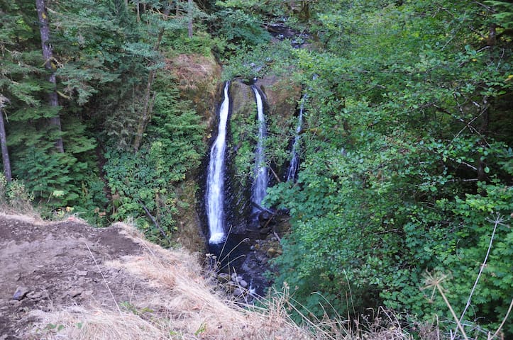
Waterfall Alley
Waterfall alley Trails
Park Overview
Located just off the Columbia River Highway, at the site of an old lumber mill, this state park features two short hikes, one to beautiful Bridal Veil Falls and the other showcasing views of the Columbia River.
The lower trail is a steep, 0.3-mile descent to the base of the magnificent waterfall. The falls duck under the Old Columbia River Gorge Highway's 1914 bridge and over mossy basalt in two tiers, a drop of about 120 feet altogether.
Hikers will pass over Bridal Veil Creek, which originates in nearby Larch Mountain and was once nearly dry, its water diverted by the Bridal Veil Falls Lumbering Company. Watch for several signs of the property’s mill days: a dike and human-made creek, remnants of old buildings and a corrugated iron shed, the last remaining structure.
WARNING: Do not try to walk along the bridge over the Historic Highway to see the falls. The road is a narrow two-lane passage with no sidewalk. PLEASE view the falls from the trail.
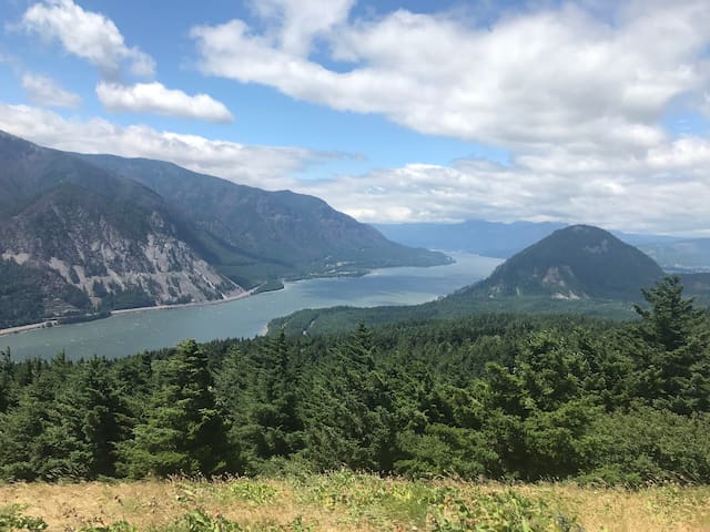
The ½-mile Overlook Trail offers magnificent views of the Columbia River along the paved loop. You’ll see dramatic rock formations, including Archer Mountain, Hamilton Mountain, Beacon Rock and the famous geologic edifice known as Pillars of Hercules. The trail also passes a patch of forest scarred by the 2017 Eagle Creek Fire.
Signs along the trail point out distinctive native wild plants that grow abundantly in this area, such as camas, lupine, bead lily, trillium and bleeding heart.
Picnic tables and restrooms are within easy walking distance from the parking area. A large lawn afford visitors a chance to stretch a blanket in one of the laziest parts of the Columbia River Gorge.
22 polecane przez mieszkańców
Bridal Veil Falls
Park Overview
Located just off the Columbia River Highway, at the site of an old lumber mill, this state park features two short hikes, one to beautiful Bridal Veil Falls and the other showcasing views of the Columbia River.
The lower trail is a steep, 0.3-mile descent to the base of the magnificent waterfall. The falls duck under the Old Columbia River Gorge Highway's 1914 bridge and over mossy basalt in two tiers, a drop of about 120 feet altogether.
Hikers will pass over Bridal Veil Creek, which originates in nearby Larch Mountain and was once nearly dry, its water diverted by the Bridal Veil Falls Lumbering Company. Watch for several signs of the property’s mill days: a dike and human-made creek, remnants of old buildings and a corrugated iron shed, the last remaining structure.
WARNING: Do not try to walk along the bridge over the Historic Highway to see the falls. The road is a narrow two-lane passage with no sidewalk. PLEASE view the falls from the trail.
The ½-mile Overlook Trail offers magnificent views of the Columbia River along the paved loop. You’ll see dramatic rock formations, including Archer Mountain, Hamilton Mountain, Beacon Rock and the famous geologic edifice known as Pillars of Hercules. The trail also passes a patch of forest scarred by the 2017 Eagle Creek Fire.
Signs along the trail point out distinctive native wild plants that grow abundantly in this area, such as camas, lupine, bead lily, trillium and bleeding heart.
Picnic tables and restrooms are within easy walking distance from the parking area. A large lawn afford visitors a chance to stretch a blanket in one of the laziest parts of the Columbia River Gorge.
Guy W. Talbot State Park — also called Latourell State Park — is a peaceful picnic site located on the Historic Columbia River Highway across from the trail to Upper Latourell Falls.
The secluded park is often uncrowded even on the best days. A modern picnic shelter is available for rent. A gently sloping grassy hill dotted with Port Orford cedars, Douglas-firs, alders and maples invites frisbee tossing and quiet relaxation.
Visitors can take a short walk underneath an historic 1914 bridge to the base of Lower Latourell Falls, a 224-foot plunge over columnar basalt splashed with chartreuse-colored lichen.
Latourell Falls Loop hike: For a moderately difficult hike, take a short staircase up to the highway and carefully cross over to the Latourell Falls Loop trailhead. This popular 2-mile trail passes over some rocky areas, through dense foliage and over four small wooden bridges, then follows Henderson Creek. Finally, hikers arrive at Upper Latourell Falls, the third tallest waterfall in the Columbia Gorge. It’s a two-tiered drop: first a block fall that’s almost hidden and then a plunge into a pool. The hike returns to the highway along the opposite bank of Henderson Creek.
Guy Webster Talbot and his family used this property as a summer estate until 1929 when they donated it to the state. The tiny town of Latourell borders the north side of the park. Homeowners ask that visitors please respect their privacy.
The upper falls and part of the trail are part of George W. Joseph State Natural Area, named for the family that gave the land to the state in 1934 and 1942.
42 polecane przez mieszkańców
Latourell Falls
Guy W. Talbot State Park — also called Latourell State Park — is a peaceful picnic site located on the Historic Columbia River Highway across from the trail to Upper Latourell Falls.
The secluded park is often uncrowded even on the best days. A modern picnic shelter is available for rent. A gently sloping grassy hill dotted with Port Orford cedars, Douglas-firs, alders and maples invites frisbee tossing and quiet relaxation.
Visitors can take a short walk underneath an historic 1914 bridge to the base of Lower Latourell Falls, a 224-foot plunge over columnar basalt splashed with chartreuse-colored lichen.
Latourell Falls Loop hike: For a moderately difficult hike, take a short staircase up to the highway and carefully cross over to the Latourell Falls Loop trailhead. This popular 2-mile trail passes over some rocky areas, through dense foliage and over four small wooden bridges, then follows Henderson Creek. Finally, hikers arrive at Upper Latourell Falls, the third tallest waterfall in the Columbia Gorge. It’s a two-tiered drop: first a block fall that’s almost hidden and then a plunge into a pool. The hike returns to the highway along the opposite bank of Henderson Creek.
Guy Webster Talbot and his family used this property as a summer estate until 1929 when they donated it to the state. The tiny town of Latourell borders the north side of the park. Homeowners ask that visitors please respect their privacy.
The upper falls and part of the trail are part of George W. Joseph State Natural Area, named for the family that gave the land to the state in 1934 and 1942.
Wahkeena Falls Loop is a beautiful experience located in the Columbia River Gorge National Scenic Area that brings hikers to one of the best waterfalls on the Oregon side. Start from the Wahkeena Picnic Area and take Wahkeena Trail #420 which passes by several waterfalls and ascends Wahkeena Creek past the springs which feed the waterfall, then continue onto Larch Mountain Trail #441 to get to Multnomah Falls.
The trail then descends down to the Multnomah Falls Lodge and returns via Return Trail #442 along The Historic Columbia River Highway to the Wahkeena parking lot. The parking area may be closed at times due to landslide risk or road maintenance. Weisendanger Falls, Ecola Falls and Fairy Falls are three of the other popular falls along this route.
21 polecane przez mieszkańców
Wahkeena Falls
Wahkeena Trail #420Wahkeena Falls Loop is a beautiful experience located in the Columbia River Gorge National Scenic Area that brings hikers to one of the best waterfalls on the Oregon side. Start from the Wahkeena Picnic Area and take Wahkeena Trail #420 which passes by several waterfalls and ascends Wahkeena Creek past the springs which feed the waterfall, then continue onto Larch Mountain Trail #441 to get to Multnomah Falls.
The trail then descends down to the Multnomah Falls Lodge and returns via Return Trail #442 along The Historic Columbia River Highway to the Wahkeena parking lot. The parking area may be closed at times due to landslide risk or road maintenance. Weisendanger Falls, Ecola Falls and Fairy Falls are three of the other popular falls along this route.
At 620 ft and Oregon's tallest waterfall, Multnomah Falls is a great attraction very close to Portland (~30 min). This is the most visited natural recreation site in the Pacific Northwest! The route shown here is a beautiful hike with a quick but steep ascent to the top of the falls.
The trail on this page starts at the large parking area along Columbia River Highway. The classic photo opportunity of Multnomah Falls is immediately accessible after parking. Definitely plan on an early arrival due to parking and heavy use.
The bridge that crosses in front of the waterfall is just a few minutes worth of scrambling after the entrance. The remainder of the hike is to the top, for a small platform vantage point, which is very worthwhile.
Located at the base of the waterfall, Multnomah Falls Lodge was built in 1925 and features an ADA-compliant visitor center, gift shop, bathrooms, and restaurant.
974 polecane przez mieszkańców
Multnomah Falls station
At 620 ft and Oregon's tallest waterfall, Multnomah Falls is a great attraction very close to Portland (~30 min). This is the most visited natural recreation site in the Pacific Northwest! The route shown here is a beautiful hike with a quick but steep ascent to the top of the falls.
The trail on this page starts at the large parking area along Columbia River Highway. The classic photo opportunity of Multnomah Falls is immediately accessible after parking. Definitely plan on an early arrival due to parking and heavy use.
The bridge that crosses in front of the waterfall is just a few minutes worth of scrambling after the entrance. The remainder of the hike is to the top, for a small platform vantage point, which is very worthwhile.
Located at the base of the waterfall, Multnomah Falls Lodge was built in 1925 and features an ADA-compliant visitor center, gift shop, bathrooms, and restaurant.
This trail includes beautiful views of the waterfalls. While Horsetail Falls is fairly easily accessible from the road, the trail to Ponytail Falls is further along and rocky. It is very cool to be able to walk behind Ponytail Falls, but use caution as it may be slippery! The trail is rocky, narrow and uneven, so it is recommended to wear proper footwear. Furthermore, this is a popular trail that may be busy on weekends.
40 polecane przez mieszkańców
Horsetail Falls
This trail includes beautiful views of the waterfalls. While Horsetail Falls is fairly easily accessible from the road, the trail to Ponytail Falls is further along and rocky. It is very cool to be able to walk behind Ponytail Falls, but use caution as it may be slippery! The trail is rocky, narrow and uneven, so it is recommended to wear proper footwear. Furthermore, this is a popular trail that may be busy on weekends.
The hike to Triple Falls takes you up the Oneonta Gorge, almost always on a steep slope and, in a couple of places, prone to perennial slides. Once you get above the gorge itself, you'll be hiking in an area severely burned in the 2017 Eagle Creek Fire. The fire raged along the creek and, at least until Triple Falls, there is no longer a forest canopy. The waterfall remains one of the most popular destinations in the Columbia River Gorge, and a new bridge was installed over Oneonta Creek in 2021 if you're interested in hiking farther up this wilderness valley (see the Larch Mountain via Oneonta Trail Hike).
Starting from the Oneonta Trailhead, the Oneonta Trail rises, paralleling the old highway and then crossing a slide gully that seems to reinvent itself every winter. When you reach the Oneonta-Gorge Trail Junction, make a left and traverse to get good views across the Columbia River to Archer Mountain. You'll recross the slide gully, passing below a flimsy perennial waterfall dripping over a mossy cliff. The trail drops below a basalt pinnacle, offering more views across the river. As you hike above a brushy bench, you'll notice a trail leading down which offers an overlook of the mouth of the Oneonta Gorge. Here, the main trail turns up the gorge, entering an area of scorched snags and views to the narrow cleft of the lower box canyon. After passing a trailside spring, you'll reach the junction where the Horsetail Falls Trail #438 heads downhill to the Middle Oneonta Falls and the first Oneonta Creek Bridge.
From the junction, the Oneonta Trail passes a wilderness permit box and a sign indicating entry to the Mark O. Hatfield Wilderness. A substantial seasonal waterfall appears across Oneonta Creek. You'll cross another slide gully, which may necessitate some care if it has been recently active. The trail climbs to a pair of switchbacks as it traverses high above the amphitheater of Oneonta Falls, also known as Upper Oneonta Falls. You can see the very top of these falls from the trail. (A short, sometimes sketchy scramble path used to angle down to the falls from the main trail just below the switchbacks, but this has disappeared since the Eagle Creek Fire.) Above the falls and across the creek, a steeply plunging stream disgorges into its own debris fan. You'll switchback up twice under a dripping rock face and traverse a steep slope high above Oneonta Creek. High above and across the creek, you can see the crest of Horsetail Ridge, totally scorched during the 2017 fire.
A short side trail breaks left and descends to a clifftop view of Triple Falls. Keep your kids and dogs in hand as you gaze across to the three plumes of the waterfall, with the hiker bridge crossing Oneonta Creek just above it.
Triple Falls
The hike to Triple Falls takes you up the Oneonta Gorge, almost always on a steep slope and, in a couple of places, prone to perennial slides. Once you get above the gorge itself, you'll be hiking in an area severely burned in the 2017 Eagle Creek Fire. The fire raged along the creek and, at least until Triple Falls, there is no longer a forest canopy. The waterfall remains one of the most popular destinations in the Columbia River Gorge, and a new bridge was installed over Oneonta Creek in 2021 if you're interested in hiking farther up this wilderness valley (see the Larch Mountain via Oneonta Trail Hike).
Starting from the Oneonta Trailhead, the Oneonta Trail rises, paralleling the old highway and then crossing a slide gully that seems to reinvent itself every winter. When you reach the Oneonta-Gorge Trail Junction, make a left and traverse to get good views across the Columbia River to Archer Mountain. You'll recross the slide gully, passing below a flimsy perennial waterfall dripping over a mossy cliff. The trail drops below a basalt pinnacle, offering more views across the river. As you hike above a brushy bench, you'll notice a trail leading down which offers an overlook of the mouth of the Oneonta Gorge. Here, the main trail turns up the gorge, entering an area of scorched snags and views to the narrow cleft of the lower box canyon. After passing a trailside spring, you'll reach the junction where the Horsetail Falls Trail #438 heads downhill to the Middle Oneonta Falls and the first Oneonta Creek Bridge.
From the junction, the Oneonta Trail passes a wilderness permit box and a sign indicating entry to the Mark O. Hatfield Wilderness. A substantial seasonal waterfall appears across Oneonta Creek. You'll cross another slide gully, which may necessitate some care if it has been recently active. The trail climbs to a pair of switchbacks as it traverses high above the amphitheater of Oneonta Falls, also known as Upper Oneonta Falls. You can see the very top of these falls from the trail. (A short, sometimes sketchy scramble path used to angle down to the falls from the main trail just below the switchbacks, but this has disappeared since the Eagle Creek Fire.) Above the falls and across the creek, a steeply plunging stream disgorges into its own debris fan. You'll switchback up twice under a dripping rock face and traverse a steep slope high above Oneonta Creek. High above and across the creek, you can see the crest of Horsetail Ridge, totally scorched during the 2017 fire.
A short side trail breaks left and descends to a clifftop view of Triple Falls. Keep your kids and dogs in hand as you gaze across to the three plumes of the waterfall, with the hiker bridge crossing Oneonta Creek just above it.
Check out this 1.9-mile out-and-back trail near Cascade Locks, Oregon. Generally considered an easy route, it takes an average of 47 min to complete. This is a very popular area for birding, hiking, and trail running, so you'll likely encounter other people while exploring. The trail is open year-round and is beautiful to visit anytime. Dogs are welcome, but must be on a leash.
16 polecane przez mieszkańców
Wahclella Falls
Check out this 1.9-mile out-and-back trail near Cascade Locks, Oregon. Generally considered an easy route, it takes an average of 47 min to complete. This is a very popular area for birding, hiking, and trail running, so you'll likely encounter other people while exploring. The trail is open year-round and is beautiful to visit anytime. Dogs are welcome, but must be on a leash.
Sightseeing
The Vista House was built in 1917 on one of the most beautiful scenic points on the Historic Columbia River Highway. It was constructed to provide travelers a place to rest and refresh themselves as they made their way down the magnificent Columbia River Gorge. Learn More History Here.
The Friends of Vista House is a non-profit group in partnership with Oregon State Parks who work to help preserve and share the story of this beautiful historic Oregon structure. Our volunteers provide visitors with regional and interpretive information to help make their visit a valuable experience.
Information about the educational exhibits and displays relating to the building is available. Our volunteers provide special building tours and talks to school, civic, and tourist groups. Visitors learn about the architecture of Vista House, the Historic Columbia River Highway, the Columbia River Gorge, local history, the geology, flora and fauna of the region, and the many wonderful attractions along the Highway and throughout the Gorge.
The Vista House has recently been approved as Bike Friendly.
Our Friends of Vista House Gift Gallery offers visitors high quality regional artwork and local gift items and is open throughout the spring, summer, and fall seasons. Our Espresso bar serves refreshments and snacks for travelers and is open year round (winter weekends, weather permitting).
131 polecane przez mieszkańców
Vista House
40700 Historic Columbia River HwyThe Vista House was built in 1917 on one of the most beautiful scenic points on the Historic Columbia River Highway. It was constructed to provide travelers a place to rest and refresh themselves as they made their way down the magnificent Columbia River Gorge. Learn More History Here.
The Friends of Vista House is a non-profit group in partnership with Oregon State Parks who work to help preserve and share the story of this beautiful historic Oregon structure. Our volunteers provide visitors with regional and interpretive information to help make their visit a valuable experience.
Information about the educational exhibits and displays relating to the building is available. Our volunteers provide special building tours and talks to school, civic, and tourist groups. Visitors learn about the architecture of Vista House, the Historic Columbia River Highway, the Columbia River Gorge, local history, the geology, flora and fauna of the region, and the many wonderful attractions along the Highway and throughout the Gorge.
The Vista House has recently been approved as Bike Friendly.
Our Friends of Vista House Gift Gallery offers visitors high quality regional artwork and local gift items and is open throughout the spring, summer, and fall seasons. Our Espresso bar serves refreshments and snacks for travelers and is open year round (winter weekends, weather permitting).
No trip to Vista House is complete without a stop at Portland Women’s Forum for a stunning view of the historic landmark framed by the Columbia River Gorge.
The same view that attracts visitors from around the globe inspired the visionaries of the Historic Columbia River Highway, built in 1918 as the first road linking Portland and The Dalles. This small park’s namesake organization, the Portland Women’s Forum, was active in preserving the natural beauty along the Gorge and donated the land to the state. Come see for yourself why this is one of the most popular viewpoints for photographing Vista House.
The viewpoint closes nightly at 9 p.m. and reopens at 6 a.m.
13 polecane przez mieszkańców
Punkt widokowy stanu Portland Women's Forum Scenic
39210 Historic Columbia River HighwayNo trip to Vista House is complete without a stop at Portland Women’s Forum for a stunning view of the historic landmark framed by the Columbia River Gorge.
The same view that attracts visitors from around the globe inspired the visionaries of the Historic Columbia River Highway, built in 1918 as the first road linking Portland and The Dalles. This small park’s namesake organization, the Portland Women’s Forum, was active in preserving the natural beauty along the Gorge and donated the land to the state. Come see for yourself why this is one of the most popular viewpoints for photographing Vista House.
The viewpoint closes nightly at 9 p.m. and reopens at 6 a.m.
The Multnomah Falls Lodge restaurant, gift shop, snack bar and restrooms are open to the public. Timed Use Permits are required May 24 through September 5, 2022.
Multnomah Falls is the most visited natural recreation site in the Pacific Northwest with more than 2 million stopping by each year to take in the views. Fed by underground springs from Larch Mountain, the flow over the falls varies, but is usually highest during winter and spring. This is also one of the best places in the Columbia River Gorge National Scenic Area to study geology exposed by floods.
The Multnomah Falls Lodge, which is run by a concessionaire, is well maintained with restrooms, a Visitor Center, a snack bar, a gift shop and a restaurant that is fully ADA accessible. The visitor information area within the lodge is jointly staffed by Friends of Multnomah Falls and the U.S. Forest Service. Offerings include a free simple trail map and free brochures about Multnomah Falls in multiple languages. Books, detailed maps of the Columbia River Gorge & Pacific Northwest, and Northwest Forest Passes are also available for purchase.
On the lower level of Multnomah Falls Lodge is a U.S. Forest Service Visitor Center, snack bar, gift shop and restrooms. The restaurant is located on the upper level and can be accessed by stairs or elevator.
974 polecane przez mieszkańców
Multnomah Falls station
The Multnomah Falls Lodge restaurant, gift shop, snack bar and restrooms are open to the public. Timed Use Permits are required May 24 through September 5, 2022.
Multnomah Falls is the most visited natural recreation site in the Pacific Northwest with more than 2 million stopping by each year to take in the views. Fed by underground springs from Larch Mountain, the flow over the falls varies, but is usually highest during winter and spring. This is also one of the best places in the Columbia River Gorge National Scenic Area to study geology exposed by floods.
The Multnomah Falls Lodge, which is run by a concessionaire, is well maintained with restrooms, a Visitor Center, a snack bar, a gift shop and a restaurant that is fully ADA accessible. The visitor information area within the lodge is jointly staffed by Friends of Multnomah Falls and the U.S. Forest Service. Offerings include a free simple trail map and free brochures about Multnomah Falls in multiple languages. Books, detailed maps of the Columbia River Gorge & Pacific Northwest, and Northwest Forest Passes are also available for purchase.
On the lower level of Multnomah Falls Lodge is a U.S. Forest Service Visitor Center, snack bar, gift shop and restrooms. The restaurant is located on the upper level and can be accessed by stairs or elevator.
Wahkeena Falls is day use area and trail situated at the base of beautiful Wahkeena Falls, just west of Multnomah Falls on the Historic Columbia River Highway. One of stops along the famed waterfall area on the Historic Highway, it connnects with a network of trails that make for great day hike loop opportunities, and world-class scenery. The 242-foot falls is a tiered type of waterfall, named after the Yakama word for "most beautiful". While not as tall as nearby Multnomah, it is no less lovely.
Wakheena Falls and several trailheads are located south of the highway, where an accessible overlook provides a prime view and photo opp for visitors. Nearby trailheads include Wahkeena Trail #420, Gorge #400 Trail, and a short Return Trail that can be used to hike to nearby Multnomah Falls.
Amenities at the picnic area (north of the highway) include a large picnic shelter with a stone fireplace, along with accessible picnic tables and fire rings.
Many people ask about reservations for weddings. This is a first-come, first-served area. If the group will be larger than 75 people, a special use permit is required.
21 polecane przez mieszkańców
Wahkeena Falls
Wahkeena Trail #420Wahkeena Falls is day use area and trail situated at the base of beautiful Wahkeena Falls, just west of Multnomah Falls on the Historic Columbia River Highway. One of stops along the famed waterfall area on the Historic Highway, it connnects with a network of trails that make for great day hike loop opportunities, and world-class scenery. The 242-foot falls is a tiered type of waterfall, named after the Yakama word for "most beautiful". While not as tall as nearby Multnomah, it is no less lovely.
Wakheena Falls and several trailheads are located south of the highway, where an accessible overlook provides a prime view and photo opp for visitors. Nearby trailheads include Wahkeena Trail #420, Gorge #400 Trail, and a short Return Trail that can be used to hike to nearby Multnomah Falls.
Amenities at the picnic area (north of the highway) include a large picnic shelter with a stone fireplace, along with accessible picnic tables and fire rings.
Many people ask about reservations for weddings. This is a first-come, first-served area. If the group will be larger than 75 people, a special use permit is required.
Named for its characteristic form, Horsetail Falls plunges 176 feet within view of the Historic Columbia River Highway's "Waterfall Corridor." Just east of the falls is a great picnic spot to enjoy the beauty of the surrounding area.
This is also a trailhead for Horsetail Falls Trail #438, a short but steep hike that passes behind the base of Upper Horsetail Falls (also called Ponytail Falls) and through a basalt half-tunnel before leading to Oneonta Trail #424. Be aware there are steep cliffs in places, so use caution. The Horsetail Falls Trailhead is also used by a section of Gorge Trail #400.
The parking area provides accessible (ADA) parking spots, however visitors will need to cross the Historic Columbia River Highway to access the viewing area and picnic tables.
40 polecane przez mieszkańców
Horsetail Falls
Named for its characteristic form, Horsetail Falls plunges 176 feet within view of the Historic Columbia River Highway's "Waterfall Corridor." Just east of the falls is a great picnic spot to enjoy the beauty of the surrounding area.
This is also a trailhead for Horsetail Falls Trail #438, a short but steep hike that passes behind the base of Upper Horsetail Falls (also called Ponytail Falls) and through a basalt half-tunnel before leading to Oneonta Trail #424. Be aware there are steep cliffs in places, so use caution. The Horsetail Falls Trailhead is also used by a section of Gorge Trail #400.
The parking area provides accessible (ADA) parking spots, however visitors will need to cross the Historic Columbia River Highway to access the viewing area and picnic tables.
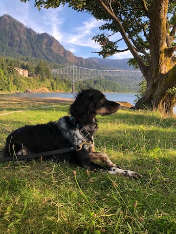
The Marine Park welcomes thousands of visitors each year for sailing, fishing, camping, picnicking, and special events. The Marine Park is the perfect place to enjoy the breathtaking views of the Columbia River Gorge. Park amenities include free parking, a children’s playground, open lawns, picnic tables, public restrooms, beach, boat ramp, and marina.
While you’re at the park, plan to tour the Cascade Locks Historical Museum and take a sightseeing cruise aboard the Columbia Gorge Sternwheeler riverboat. Within the park, you will find a footbridge over the historic locks and canal to Thunder Island in the Columbia River. The island is open to the public, and provides unique views of the Bridge of the Gods just downriver.
Cascade Locks Marine Park
355 Wa Na Pa StThe Marine Park welcomes thousands of visitors each year for sailing, fishing, camping, picnicking, and special events. The Marine Park is the perfect place to enjoy the breathtaking views of the Columbia River Gorge. Park amenities include free parking, a children’s playground, open lawns, picnic tables, public restrooms, beach, boat ramp, and marina.
While you’re at the park, plan to tour the Cascade Locks Historical Museum and take a sightseeing cruise aboard the Columbia Gorge Sternwheeler riverboat. Within the park, you will find a footbridge over the historic locks and canal to Thunder Island in the Columbia River. The island is open to the public, and provides unique views of the Bridge of the Gods just downriver.
City/town information
Follow the Historic Columbia River Highway as it weaves past famous waterfalls and right into town. Located on the banks of the breathtaking Columbia River, Cascade Locks is home to the Sternwheeler Columbia Gorge, which hosts daily and nightly cruises. Catch all the action from Thunder Island with local craft beer or a handmade milkshake and enjoy the city’s unparalleled views.
29 polecane przez mieszkańców
Cascade Locks
Follow the Historic Columbia River Highway as it weaves past famous waterfalls and right into town. Located on the banks of the breathtaking Columbia River, Cascade Locks is home to the Sternwheeler Columbia Gorge, which hosts daily and nightly cruises. Catch all the action from Thunder Island with local craft beer or a handmade milkshake and enjoy the city’s unparalleled views.
With its mix of warm, sunny days and crisp, sprinkly weather, fall is a great time to get outside and experience firsthand the changing of the seasons. That’s especially the case in Hood River, when the summer crowds peter out, the riverfront trees change colors and the farms and orchards pop with the bounty of harvest season. To skip the hassle of driving and parking, consider a car-free trip via one of many bus, shuttle, train and bike routes. Here’s everything you need to know to plan the ultimate fall trip to Hood River. Whenever you’re visiting, make sure to have a Plan B and C ready in case Plan A is too crowded.
218 polecane przez mieszkańców
Hood River
With its mix of warm, sunny days and crisp, sprinkly weather, fall is a great time to get outside and experience firsthand the changing of the seasons. That’s especially the case in Hood River, when the summer crowds peter out, the riverfront trees change colors and the farms and orchards pop with the bounty of harvest season. To skip the hassle of driving and parking, consider a car-free trip via one of many bus, shuttle, train and bike routes. Here’s everything you need to know to plan the ultimate fall trip to Hood River. Whenever you’re visiting, make sure to have a Plan B and C ready in case Plan A is too crowded.
Known as the gateway to the Columbia River Gorge, the town of Troutdale perches at the confluence of the Sandy and Columbia rivers just outside of Portland. It marks the start of 80 miles of dramatic beauty — the river winding from the east, sheer gorge cliffs and a string of rushing waterfalls. Before heading out to explore the Gorge, get a feel for friendly Troutdale.
18 polecane przez mieszkańców

Troutdale
Known as the gateway to the Columbia River Gorge, the town of Troutdale perches at the confluence of the Sandy and Columbia rivers just outside of Portland. It marks the start of 80 miles of dramatic beauty — the river winding from the east, sheer gorge cliffs and a string of rushing waterfalls. Before heading out to explore the Gorge, get a feel for friendly Troutdale.
Food scene
Thunder Island Brewing Company
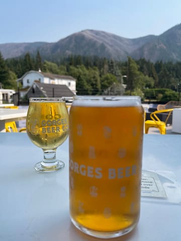
Gorges Beer Co.
390 Wa Na Pa StreetBrigham Fish Market
681 Wa Na Pa StThe way out inn is now LoLos. Same great pizza new name.
11 polecane przez mieszkańców
The Way Out Inn
275 E Columbia River HwyThe way out inn is now LoLos. Same great pizza new name.
Sugarpine Drive-In
1208 E Historic Columbia River HwyMcMenamins Edgefield Winery Tasting Room
2126 SW Halsey StGood Coffee
4747 SE Division StHistoric, good for a nearby meal but I recommend Troutdale restaurants listed or Cascade Locks.
33 polecane przez mieszkańców
Multnomah Falls Lodge
53000 Historic Columbia River HwyHistoric, good for a nearby meal but I recommend Troutdale restaurants listed or Cascade Locks.
Other nearby trails
Want to find the best trails in Beacon Rock State Park for an adventurous hike or a family trip? AllTrails has 11 great hiking trails, biking trails, running trails and more. Enjoy hand-curated trail maps, along with reviews and photos from nature lovers like you.
Ready for your next hike or bike ride? Explore one of 2 easy hiking trails in Beacon Rock State Park that are great for the whole family. Looking for a more strenuous hike? We've got you covered, with trails ranging from 22 to 3,487 feet in elevation gain. Whatever you have planned for the day, you can find the perfect trail for your next trip to Beacon Rock State Park.
29 polecane przez mieszkańców
Beacon Rock Trailhead
Beacon Rock TrailWant to find the best trails in Beacon Rock State Park for an adventurous hike or a family trip? AllTrails has 11 great hiking trails, biking trails, running trails and more. Enjoy hand-curated trail maps, along with reviews and photos from nature lovers like you.
Ready for your next hike or bike ride? Explore one of 2 easy hiking trails in Beacon Rock State Park that are great for the whole family. Looking for a more strenuous hike? We've got you covered, with trails ranging from 22 to 3,487 feet in elevation gain. Whatever you have planned for the day, you can find the perfect trail for your next trip to Beacon Rock State Park.
Experience this 6.5-mile loop trail near Carson, Washington. Generally considered a challenging route, it takes an average of 5 h 1 min to complete. This is a very popular area for hiking and trail running, so you'll likely encounter other people while exploring. The best times to visit this trail are March through November. Dogs are welcome, but must be on a leash.
24 polecane przez mieszkańców
Dog Mountain
Experience this 6.5-mile loop trail near Carson, Washington. Generally considered a challenging route, it takes an average of 5 h 1 min to complete. This is a very popular area for hiking and trail running, so you'll likely encounter other people while exploring. The best times to visit this trail are March through November. Dogs are welcome, but must be on a leash.
Porady dla podróżnych
Poruszanie się po okolicy
Trolley
The best way to see Multnomah Falls, Wahkeena Falls and Horsetail Falls are early hours before 9am or after 6pm.
During May through September you will require a timed pass to get through to east of Angels Rest between 9am and 6pm everyday. You may hop on the Trolley at the end of the west driveway. The link below will provide you the table. Don't worry about parking and hop on the trolley.
https://cdn.tourcms.com/a/11676/3658/12130.pdf
Zarezerwuj, zanim wyruszysz
Timed Permit
Starting May 24th through September 5th, permits will be required from 9:00 am to 6:00 pm. A Timed Use Permit reservation does not guarantee parking. Permits will be available on a per vehicle basis and visitors will be limited to 2 permits per day.
Depending on your travel plans, reserve one or both permits:
Waterfall Corridor Timed Use Permit: The Forest Service in partnership with Oregon Department of Transportation, Oregon Parks Recreation Department, and Multnomah County are piloting Timed Use Permits to access the Waterfall Corridor
https://www.recreation.gov/timed-entry/10089144
Poruszanie się po okolicy
Ebikes
https://ebikemultnomahfalls.com
Nie przegap
Hood River SUP and Kayak
https://www.hoodriversupandkayak.com
Nie przegap
Gorge Paddling Center - Rentals Hood River, Oregon
https://gorgekayaker.com
Nie przegap
Columbia Gorge Sternwheeler Cruises
https://www.portlandspirit.com/sternwheeler.php
Nie przegap
Columbia River Gorge Airplane Tour
https://www.enviadventures.com/airplane-tours/vista-view/