
Pete's Guidebook
Sightseeing
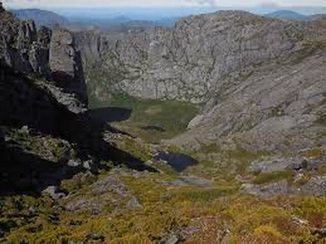
This is one of the most photographed scenes in Queenstown. You will see tourists regularly standing in the middle of Orr Street aiming their phones and other photographic devices in a easterly direction towards the rocky capped cliff top of the majestic Mount Owen.
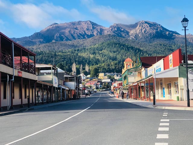
Orr Street
Orr StreetThis is one of the most photographed scenes in Queenstown. You will see tourists regularly standing in the middle of Orr Street aiming their phones and other photographic devices in a easterly direction towards the rocky capped cliff top of the majestic Mount Owen.
Mount Owen
More than a train ride
When you travel aboard the West Coast Wilderness Railway, you will be well looked after. That care extends to the beginning and end of your journey, and even to those who are simply visiting us at Queenstown Station. Enjoy a delicious snack, coffee, drink or meal at Tracks Cafe, discover the history and heritage of the Railway in our Museum, pick up a unique souvenir of your experience or gifts for family and friends at our Gift Shop and join a workshop tour to get up close and personal with our rolling stock and those who keep it rolling.
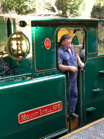
West Coast Wilderness Railway (Queenstown Station)
1 Driffield StMore than a train ride
When you travel aboard the West Coast Wilderness Railway, you will be well looked after. That care extends to the beginning and end of your journey, and even to those who are simply visiting us at Queenstown Station. Enjoy a delicious snack, coffee, drink or meal at Tracks Cafe, discover the history and heritage of the Railway in our Museum, pick up a unique souvenir of your experience or gifts for family and friends at our Gift Shop and join a workshop tour to get up close and personal with our rolling stock and those who keep it rolling.
About Galley Museum
”The Eric Thomas Galley Museum is a photographic and general museum in Driffield Street in Queenstown.One of two west coast Tasmania museums that house records and relics from the mining communities of the past, the museum is housed in a former 1897 contructed Imperial Hotel, which has also been a mining office and Youth Hostel.As a repository of the historical photographs and materials from the history of Queenstown it contains collections that hold in some cases the last vestiges of the former mines and localities on the west coast.The collection of photographs and text and materials relating to the 1912 North Mount Lyell Mining disaster is extensive.Considerable parts of the photograph collection were photographs collected by and also processed by Eric Thomas.An object from the museum was utilised in a 10 objects 10 stories exhibition in Hobart in 2016
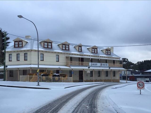
Galley Museum
7 Driffield StAbout Galley Museum
”The Eric Thomas Galley Museum is a photographic and general museum in Driffield Street in Queenstown.One of two west coast Tasmania museums that house records and relics from the mining communities of the past, the museum is housed in a former 1897 contructed Imperial Hotel, which has also been a mining office and Youth Hostel.As a repository of the historical photographs and materials from the history of Queenstown it contains collections that hold in some cases the last vestiges of the former mines and localities on the west coast.The collection of photographs and text and materials relating to the 1912 North Mount Lyell Mining disaster is extensive.Considerable parts of the photograph collection were photographs collected by and also processed by Eric Thomas.An object from the museum was utilised in a 10 objects 10 stories exhibition in Hobart in 2016
GETTING THERE
The lookout is on the eastern edge of town towards the Lyell Highway. Turn into town off the Lyell Highway onto Driffield Street. Quickly turn left onto Hunter Street before taking another left onto Bowes Street. By now you'll see the signs for the lookout at the end of LaTrobe Street.
Keep an eye out for Andrew who can be found playing bagpipes almost every Sunday at the top of the lookout. He knows how to play them.
Spion Kop Lookout
GETTING THERE
The lookout is on the eastern edge of town towards the Lyell Highway. Turn into town off the Lyell Highway onto Driffield Street. Quickly turn left onto Hunter Street before taking another left onto Bowes Street. By now you'll see the signs for the lookout at the end of LaTrobe Street.
Keep an eye out for Andrew who can be found playing bagpipes almost every Sunday at the top of the lookout. He knows how to play them.
GETTING THERE
Horsetail Falls (or “Queenstown Falls” as we used to call it) was pretty straight forward as it was right off the Lyell Highway (A10).
The roadside view that we attained was roughly 4.2km east of the Driffield Street turnoff near the centre of Queenstown (or about 700m east of the Queenstown overlook).
Horsetail Falls
GETTING THERE
Horsetail Falls (or “Queenstown Falls” as we used to call it) was pretty straight forward as it was right off the Lyell Highway (A10).
The roadside view that we attained was roughly 4.2km east of the Driffield Street turnoff near the centre of Queenstown (or about 700m east of the Queenstown overlook).
GETTING THERE
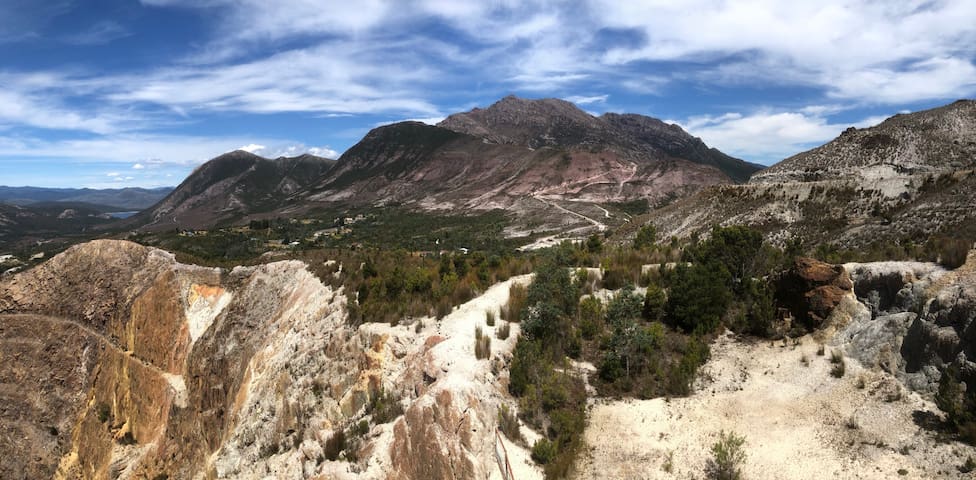
The lookout sits atop Gormonston Hill on the northern side of the Lyell Highway in the ghost town of Gormanston. Exit onto Iron Blow Road and take the paved road up the hill to the lookout. There's plenty of parking.
The Iron Blow Lookout allows you to peer into Tasmania's tortured mining history. Gold was discovered in the hills of the Linda Valley of Tasmania's west coast back in 1883 at a site dubbed the Iron Blow. Miners descended on the site to discover much more profitable deposits of copper. They then wrought destruction on the land to strip it bare before deserting the nearby mining ghost towns of Gormanston and Linda. The Iron Blow Lookout gives you a bird's eye view of the open-cut mine with the stains of mineral deposits streaking the pit's walls. It makes for a hauntingly beautiful site, but to capture the brilliance of the unnatural colours, you'll need to get here on a sunny day.
The Iron Blow is just part of the devasted-yet-beautiful landscape that surrounds the west coast city of Queenstown. Over-mining and copper smelting has stripped the land bare and stained it with mineral deposits to create a haunting moonscape that is a stark reminder of man's greed. The Iron Blow Lookout is a great introduction to this bizarre landscape as you drive west on the Lyell Highway from Hobart. The road winds its way through the Linda Valley and then descends down steep switchbacks to the bottom of the moonscape at Queenstown. The Iron Blow is a geological laceration and it was the beginning of the mining boom for the Queenstown region back in the 1800's.
Iron Blow Lookout
Iron Blow Road
GETTING THERE
The lookout sits atop Gormonston Hill on the northern side of the Lyell Highway in the ghost town of Gormanston. Exit onto Iron Blow Road and take the paved road up the hill to the lookout. There's plenty of parking.
The Iron Blow Lookout allows you to peer into Tasmania's tortured mining history. Gold was discovered in the hills of the Linda Valley of Tasmania's west coast back in 1883 at a site dubbed the Iron Blow. Miners descended on the site to discover much more profitable deposits of copper. They then wrought destruction on the land to strip it bare before deserting the nearby mining ghost towns of Gormanston and Linda. The Iron Blow Lookout gives you a bird's eye view of the open-cut mine with the stains of mineral deposits streaking the pit's walls. It makes for a hauntingly beautiful site, but to capture the brilliance of the unnatural colours, you'll need to get here on a sunny day.
The Iron Blow is just part of the devasted-yet-beautiful landscape that surrounds the west coast city of Queenstown. Over-mining and copper smelting has stripped the land bare and stained it with mineral deposits to create a haunting moonscape that is a stark reminder of man's greed. The Iron Blow Lookout is a great introduction to this bizarre landscape as you drive west on the Lyell Highway from Hobart. The road winds its way through the Linda Valley and then descends down steep switchbacks to the bottom of the moonscape at Queenstown. The Iron Blow is a geological laceration and it was the beginning of the mining boom for the Queenstown region back in the 1800's.
LAKE BURBURY
Lake Burbury is a popular fishing lake on the edge of Tasmania's World Heritage Wilderness Area.
At Lake Burbury, a 15-minute drive east of Queenstown, you can fish for the legendary Tasmanian wild trout with both brown and rainbow trout in abundance or just take in the natural beauty and serenity of the place.
Named after Stanley Burbury, the first Australian-born Governor of Tasmania, the 54 square-kilometre lake was man-made for hydro-electricity production in the early 1990s.
There are boat launching, picnic and barbecue facilities.
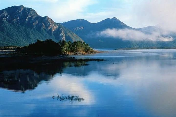
Lake Burbury
LAKE BURBURY
Lake Burbury is a popular fishing lake on the edge of Tasmania's World Heritage Wilderness Area.
At Lake Burbury, a 15-minute drive east of Queenstown, you can fish for the legendary Tasmanian wild trout with both brown and rainbow trout in abundance or just take in the natural beauty and serenity of the place.
Named after Stanley Burbury, the first Australian-born Governor of Tasmania, the 54 square-kilometre lake was man-made for hydro-electricity production in the early 1990s.
There are boat launching, picnic and barbecue facilities.
One of the most stunning views in the state is from Mt Jukes overlooking Lake Burbury with a commanding view of Frenchman’s Cap.
Mt Jukes Road is a continuation of the road through the Queenstown town centre. Continue along Driffield Street past the Railway Station.
The road then starts it’s steep ascent along the side of Mt Jukes. At the top stop to take in the magnificent view of Lake Burbury, to the left is Kelly Basin.
Continue down the Mount Jukes Road to the start of the Kelly Basin Walk or return to Queenstown.
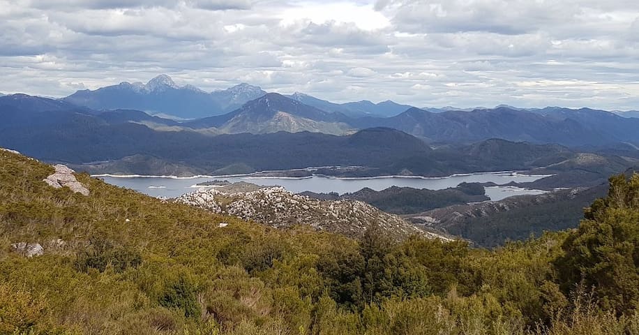
Mount Jukes
One of the most stunning views in the state is from Mt Jukes overlooking Lake Burbury with a commanding view of Frenchman’s Cap.
Mt Jukes Road is a continuation of the road through the Queenstown town centre. Continue along Driffield Street past the Railway Station.
The road then starts it’s steep ascent along the side of Mt Jukes. At the top stop to take in the magnificent view of Lake Burbury, to the left is Kelly Basin.
Continue down the Mount Jukes Road to the start of the Kelly Basin Walk or return to Queenstown.
The Confluence Queenstown is a short walk to the point where the polluted orange waters of the Queen River meet the dark waters of the King.
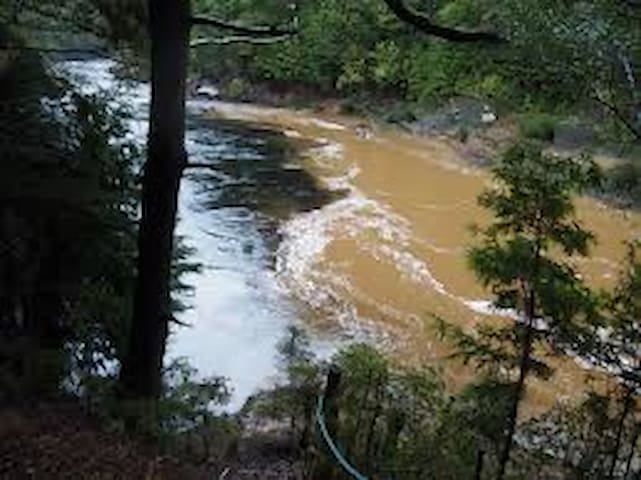
The Confluence
Mount Jukes RoadThe Confluence Queenstown is a short walk to the point where the polluted orange waters of the Queen River meet the dark waters of the King.
Self-guided Tours
Go behind the scenes of this beautiful historic theatre. Wander through the main hall, the dress circle and projection rooms. Check out the carbon-arc projectors, original movie posters and other memorabilia from the golden years of talkie theatres. Catch the 3 short video presentations detailing the history of the theatre. Take your time, grab a coffee and home-made cake at the bar and soak up the atmosphere of this wonderful art deco space.
Tours daily 10am–4pm
(Other times by arrangement)
Adults $7 Children $3
8 polecane przez mieszkańców
The Paragon Theatre
11 McNamara StSelf-guided Tours
Go behind the scenes of this beautiful historic theatre. Wander through the main hall, the dress circle and projection rooms. Check out the carbon-arc projectors, original movie posters and other memorabilia from the golden years of talkie theatres. Catch the 3 short video presentations detailing the history of the theatre. Take your time, grab a coffee and home-made cake at the bar and soak up the atmosphere of this wonderful art deco space.
Tours daily 10am–4pm
(Other times by arrangement)
Adults $7 Children $3
"The Gravel" can be found by driving along Batchelor Street, Queenstown just near the town centre where you’ll find a Motel just near a wooden bridge. Cross the bridge to gain access to the ground. The stadium is an almost surreal place when you enter, with its gravel playing surface, bitumen cycle track around it and eerie hills overlooking it, the place has a life almost of its own.
Queenstown Oval has one main grandstand which is concrete, this replaced the much larger wooden stand which was burnt down by vandals a few years ago. On the opposite side of the ground, the ramshackle looking Kevin Taylor Can Bar sits atop a lush green hill overlooking the field, the lushness of the hill looks completely out of place with the baron-ness of the rest of the place.
The Queenstown FC change rooms building is a fairly large grey brick building located on the grandstand side of the ground, in the Mt Lyell Mine end pocket.
A private house and an old wooden building which may have been another change room and kiosk many years ago sits behind the goals at the Mt Owen end.
It is quite a nice little ground, and the view from the stand is very good, as it is from the Can Bar on the hill.
It is quite amazing to see the numbers of tourists who stop to take photos of this bizarre looking ground. "The Gravel" has hosted football and community events in Queenstown for well over a century, and legend has it, that it was the first ground in Tasmania to install a siren to signal the start and end of each quarter with a siren borrowed from the Mt Lyell Mines.
It was also the grand final venue for the now extinct WTFA for almost a hundred years. The ground is home of the Queenstown Crows in the Darwin Football Association.
A richly historical ground, rugged and tough - seems in keeping with the area where it is located.
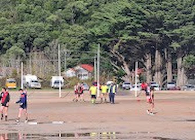
Queenstown Oval
Wilsdon Street"The Gravel" can be found by driving along Batchelor Street, Queenstown just near the town centre where you’ll find a Motel just near a wooden bridge. Cross the bridge to gain access to the ground. The stadium is an almost surreal place when you enter, with its gravel playing surface, bitumen cycle track around it and eerie hills overlooking it, the place has a life almost of its own.
Queenstown Oval has one main grandstand which is concrete, this replaced the much larger wooden stand which was burnt down by vandals a few years ago. On the opposite side of the ground, the ramshackle looking Kevin Taylor Can Bar sits atop a lush green hill overlooking the field, the lushness of the hill looks completely out of place with the baron-ness of the rest of the place.
The Queenstown FC change rooms building is a fairly large grey brick building located on the grandstand side of the ground, in the Mt Lyell Mine end pocket.
A private house and an old wooden building which may have been another change room and kiosk many years ago sits behind the goals at the Mt Owen end.
It is quite a nice little ground, and the view from the stand is very good, as it is from the Can Bar on the hill.
It is quite amazing to see the numbers of tourists who stop to take photos of this bizarre looking ground. "The Gravel" has hosted football and community events in Queenstown for well over a century, and legend has it, that it was the first ground in Tasmania to install a siren to signal the start and end of each quarter with a siren borrowed from the Mt Lyell Mines.
It was also the grand final venue for the now extinct WTFA for almost a hundred years. The ground is home of the Queenstown Crows in the Darwin Football Association.
A richly historical ground, rugged and tough - seems in keeping with the area where it is located.
GETTING THERE
23422 Lyell Highway, Royal Hotel Linda
Gormanston, 7466
Tasmania
Linda Cafe is nestled in the Linda Valley beside the Royal Hotel Linda. Enter via Sadler Street for real food, beverages and West Coast hospitality.
Specialising in great coffee, bagels and house made treats.
Follow @royal_hotel_linda for information on the renovation of the Royal Hotel ruin.
Linda Cafe featuring the best of Tasmanian produce served in a beautiful cafe nestled beside the ruin of the Royal Hotel Linda.
Entrepreneur Zara Trihey and her brothers are creating something amazing from the evocative ruin of Linda’s Royal Hotel.
Located on the Lyell Highway, it is the perfect rest place between Derwent Bridge and Queenstown / Strahan.

Linda Cafe
23422 Lyell HighwayGETTING THERE
23422 Lyell Highway, Royal Hotel Linda
Gormanston, 7466
Tasmania
Linda Cafe is nestled in the Linda Valley beside the Royal Hotel Linda. Enter via Sadler Street for real food, beverages and West Coast hospitality.
Specialising in great coffee, bagels and house made treats.
Follow @royal_hotel_linda for information on the renovation of the Royal Hotel ruin.
Linda Cafe featuring the best of Tasmanian produce served in a beautiful cafe nestled beside the ruin of the Royal Hotel Linda.
Entrepreneur Zara Trihey and her brothers are creating something amazing from the evocative ruin of Linda’s Royal Hotel.
Located on the Lyell Highway, it is the perfect rest place between Derwent Bridge and Queenstown / Strahan.
Getting there
When heading out Tullah towards Roseberry head for Anthony Rd ( link Rd to Queenstown ) follow that for a good 5km or so.
You wil notice a sign when aproaching the track with a car park on the left and the track on the right.
Mount Murchison is a mountain on the West Coast Range, located in the West Coast region of Tasmania, Australia. At 1,275 metres above sea level, it is the highest mountain in the range and within the top thirty highest mountains in Tasmania.
Route/Trail notes
Steep , rocky , boulders to scarmble over but you'l have a breather in bewteen when reaching the plateau at about 800m
Mount Murchison
Getting there
When heading out Tullah towards Roseberry head for Anthony Rd ( link Rd to Queenstown ) follow that for a good 5km or so.
You wil notice a sign when aproaching the track with a car park on the left and the track on the right.
Mount Murchison is a mountain on the West Coast Range, located in the West Coast region of Tasmania, Australia. At 1,275 metres above sea level, it is the highest mountain in the range and within the top thirty highest mountains in Tasmania.
Route/Trail notes
Steep , rocky , boulders to scarmble over but you'l have a breather in bewteen when reaching the plateau at about 800m
GETTING THERE
Montezuma Falls are about 1 hour 15 mins drive from both Strahan and Queestown via the Murchison Highway (A10).
Where possible, please avoid driving in our reserves at night. You are sharing the roads with our native wildlife, so take it slow and watch out for animals on the road.
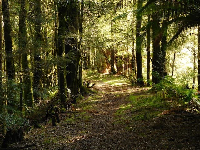
You might expect a waterfall named after a powerful Aztec emperor to be grand, and in this case you’d be right. This walk follows a former tramway through wet, steep, thickly forested west coast country to one of the highest falls in Tasmania. It’s amazing to ponder how they ever built a tramway here. The track eventually comes right to the base of the 104m high falls, and to a bridge that offers great views back to the falls, and out to the wild western rainforests. Return via the same track.
Walking from Williamsford, the track is almost entirely through pleasant and open park-like rainforest. This includes leatherwood, myrtle, sassafras, giant tree ferns and eye-catching fungi.
You’re sure to get close to several different birds along the way, notably White’s thrush, which is a medium-sized, speckled brown and white ground dwelling bird. It forages quietly on the rainforest floor and, when disturbed, flies only a short distance before settling again, enabling you to get a second look.
6 polecane przez mieszkańców
Montezuma Falls
1 Elliott StGETTING THERE
Montezuma Falls are about 1 hour 15 mins drive from both Strahan and Queestown via the Murchison Highway (A10).
Where possible, please avoid driving in our reserves at night. You are sharing the roads with our native wildlife, so take it slow and watch out for animals on the road.
You might expect a waterfall named after a powerful Aztec emperor to be grand, and in this case you’d be right. This walk follows a former tramway through wet, steep, thickly forested west coast country to one of the highest falls in Tasmania. It’s amazing to ponder how they ever built a tramway here. The track eventually comes right to the base of the 104m high falls, and to a bridge that offers great views back to the falls, and out to the wild western rainforests. Return via the same track.
Walking from Williamsford, the track is almost entirely through pleasant and open park-like rainforest. This includes leatherwood, myrtle, sassafras, giant tree ferns and eye-catching fungi.
You’re sure to get close to several different birds along the way, notably White’s thrush, which is a medium-sized, speckled brown and white ground dwelling bird. It forages quietly on the rainforest floor and, when disturbed, flies only a short distance before settling again, enabling you to get a second look.
WELCOME TO THE WEST COAST HERITAGE CENTRE
From Mines and Memories to Trains and Treasures, the West Coast Heritage Centre offers a unique insight to the history of the West Coast of Tasmania and gives visitors a comprehensive experience and understanding of the heritage of the area, adding value and significance to your visit of this beautiful region of Tasmania.
The Centre incorporates four historic buildings- the Zeehan School of Mines and Metallurgy, Zeehan Post Office, Police Station-Court house, and the Gaiety Theatre-Grand Hotel, as well as 30 themed exhibition spaces. Explore the mining relics in our yard, experience what an underground mine was like in our Crocoite Cavern and see minerals and rocks of every size, shape and colour imaginable. You can climb aboard our historic trains, stroll through the region’s history in our photographic galleries, watch Edwardian films in the majestic Gaiety Theatre, act out a scene in our Court house or take a peek into the somewhat secretive society of Freemason’s in our Masonic Lodge display. You can even grab a souvenir in our gift shop.
7 polecane przez mieszkańców
West Coast Heritage Centre
114 Main StWELCOME TO THE WEST COAST HERITAGE CENTRE
From Mines and Memories to Trains and Treasures, the West Coast Heritage Centre offers a unique insight to the history of the West Coast of Tasmania and gives visitors a comprehensive experience and understanding of the heritage of the area, adding value and significance to your visit of this beautiful region of Tasmania.
The Centre incorporates four historic buildings- the Zeehan School of Mines and Metallurgy, Zeehan Post Office, Police Station-Court house, and the Gaiety Theatre-Grand Hotel, as well as 30 themed exhibition spaces. Explore the mining relics in our yard, experience what an underground mine was like in our Crocoite Cavern and see minerals and rocks of every size, shape and colour imaginable. You can climb aboard our historic trains, stroll through the region’s history in our photographic galleries, watch Edwardian films in the majestic Gaiety Theatre, act out a scene in our Court house or take a peek into the somewhat secretive society of Freemason’s in our Masonic Lodge display. You can even grab a souvenir in our gift shop.
GETTING THERE
The Gordon River Cruise is in the main port town of Strahan 41 kms west of Queenstown.
Our awarding-winning Gordon River Cruise is a truly immersive experience. Take in the tranquil surrounds of the Gordon River as you glide across the water in 'Whisper Mode'. Our dedicated guides and character-based interpretations will take you through the history of this remarkable place, including Macquarie Harbour, Hells Gates, Heritage Landing and Sarah Island.
23 polecane przez mieszkańców
Gordon River Cruises
24 EsplanadeGETTING THERE
The Gordon River Cruise is in the main port town of Strahan 41 kms west of Queenstown.
Our awarding-winning Gordon River Cruise is a truly immersive experience. Take in the tranquil surrounds of the Gordon River as you glide across the water in 'Whisper Mode'. Our dedicated guides and character-based interpretations will take you through the history of this remarkable place, including Macquarie Harbour, Hells Gates, Heritage Landing and Sarah Island.
In Tasmania’s west, the rivers are wild, the landscape is rugged and the mountain peaks are dramatic and imposing. Pristine fresh waters stained by tannins from surrounding vegetation weave their way through breathtaking gorges.
Water is ever-present in the Franklin-Gordon Wild Rivers National Park – trickling down from mountain peaks, running into creeks that cascade and twist through the rocks, combining to make the powerful Franklin and Gordon rivers.
Franklin-Gordon Wild Rivers National Park lies in the heart of the Tasmanian Wilderness World Heritage Area, just an hour from Strahan. Along the Lyell Highway, short walks provide easy access to view the famous Franklin River, while at Strahan, commercial cruises provide access to the magnificent Macquarie Harbour and Gordon River.
Franklin-Gordon Wild Rivers National Park
In Tasmania’s west, the rivers are wild, the landscape is rugged and the mountain peaks are dramatic and imposing. Pristine fresh waters stained by tannins from surrounding vegetation weave their way through breathtaking gorges.
Water is ever-present in the Franklin-Gordon Wild Rivers National Park – trickling down from mountain peaks, running into creeks that cascade and twist through the rocks, combining to make the powerful Franklin and Gordon rivers.
Franklin-Gordon Wild Rivers National Park lies in the heart of the Tasmanian Wilderness World Heritage Area, just an hour from Strahan. Along the Lyell Highway, short walks provide easy access to view the famous Franklin River, while at Strahan, commercial cruises provide access to the magnificent Macquarie Harbour and Gordon River.
ABOUT
Walk with history down the route of the former railway line to Kelly Basin, where remains of rail bridges and sleepers are reminders of the past.
Where once 1000 people lived, today only historic remnants of the former town of Pillinger can be seen amidst lush green mosses and tree ferns.
The walk in to Kelly Basin will take 3-4 hours return (10.8km) and during the walk you will see the deep brown tannin-stained water of Bird River, providing for some stunning photo opportunities.
There are picnic tables at the start of the track. Please note that the closest toilets are approximately 45 minutes away from the start of the walk, at the Darwin Dam boat ramp (these toilets are long drop, with no hand washing facilities).
This walk is classed at level Grade 3 - some bushwalking experience required and suitable for most ages and fitness level. Sturdy footwear is a must and please supervise children as the weather changes quickly and the track can get wet underfoot.
How to get there - in Queenstown follow Driffield Street past the train station, heading south out of town onto the sealed Mt Jukes Road (29km). Turn onto the gravel Kelly Basin Road and drive for 11km to the Bird River Bridge turnoff. This drive will take approximately an hour from Queenstown.
The track can be subject to closures in winter, please check the track is open before embarking on your journey down Mt Jukes Road.
Kelly Basin Track
Kelly Basin TrackABOUT
Walk with history down the route of the former railway line to Kelly Basin, where remains of rail bridges and sleepers are reminders of the past.
Where once 1000 people lived, today only historic remnants of the former town of Pillinger can be seen amidst lush green mosses and tree ferns.
The walk in to Kelly Basin will take 3-4 hours return (10.8km) and during the walk you will see the deep brown tannin-stained water of Bird River, providing for some stunning photo opportunities.
There are picnic tables at the start of the track. Please note that the closest toilets are approximately 45 minutes away from the start of the walk, at the Darwin Dam boat ramp (these toilets are long drop, with no hand washing facilities).
This walk is classed at level Grade 3 - some bushwalking experience required and suitable for most ages and fitness level. Sturdy footwear is a must and please supervise children as the weather changes quickly and the track can get wet underfoot.
How to get there - in Queenstown follow Driffield Street past the train station, heading south out of town onto the sealed Mt Jukes Road (29km). Turn onto the gravel Kelly Basin Road and drive for 11km to the Bird River Bridge turnoff. This drive will take approximately an hour from Queenstown.
The track can be subject to closures in winter, please check the track is open before embarking on your journey down Mt Jukes Road.
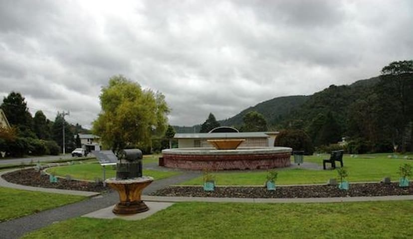
The Memorial Park commemorates the centenary of the North Lyell Mine disaster and the forty two victims who lost their lives.
Forty-two trees endemic to the region are planted in a circle around the fountain pool with a plaque featuring the name of each victim placed in front of each tree.
The 1912 North Mount Lyell Disaster (also known at the time as the Mount Lyell Disaster ) refers to a fire that broke out on 12 October 1912 at the Mount Lyell Mining and Railway Company operations on the West Coast of Tasmania. The mine had been taken over from the North Mount Lyell Company in 1903.
The fire started on a Saturday morning, between 11:15 and 11:30 am, when the pump house on the 700 ft level of the mine was reported as being on fire. Only 73 men initially made their way to safety on the first day. Initially the status of the fire, numbers casualties and survivors were confused in the first day or so. Considerable problems occurred removing men from the mine who were still alive. Many became trapped as they were working in remote stopes and didn't know of the fire until it was far too late, as there was no emergency warning system operating in the mine. Instead, men had to run along the levels and drives calling to the men, warning them of the serious danger that faced them. 170 men entered the mine that day. 42 were never to be seen
North Lyell Disaster Memorial Park
9A Railway ReserveThe Memorial Park commemorates the centenary of the North Lyell Mine disaster and the forty two victims who lost their lives.
Forty-two trees endemic to the region are planted in a circle around the fountain pool with a plaque featuring the name of each victim placed in front of each tree.
The 1912 North Mount Lyell Disaster (also known at the time as the Mount Lyell Disaster ) refers to a fire that broke out on 12 October 1912 at the Mount Lyell Mining and Railway Company operations on the West Coast of Tasmania. The mine had been taken over from the North Mount Lyell Company in 1903.
The fire started on a Saturday morning, between 11:15 and 11:30 am, when the pump house on the 700 ft level of the mine was reported as being on fire. Only 73 men initially made their way to safety on the first day. Initially the status of the fire, numbers casualties and survivors were confused in the first day or so. Considerable problems occurred removing men from the mine who were still alive. Many became trapped as they were working in remote stopes and didn't know of the fire until it was far too late, as there was no emergency warning system operating in the mine. Instead, men had to run along the levels and drives calling to the men, warning them of the serious danger that faced them. 170 men entered the mine that day. 42 were never to be seen