
Cupid's Cove Cabin Guidebook
Sightseeing
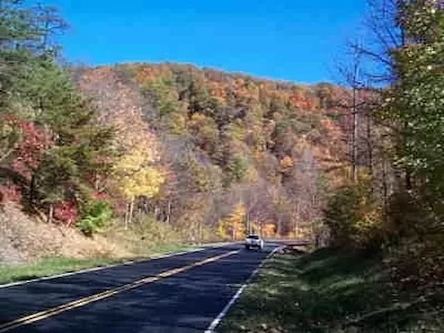
The Cherokee National Forest comprises 1/3 of the county with 189 miles of trails for hikers, bikers and horses. The Cherokee National Forest is Tennessee's only National Forest and located here is the Cherohala Skyway, one of America's newest scenic Byways.
While wilderness areas continue to dwindle or deteriorate, more and more visitors are naturally drawn to the national forest, Cherohala Skyway, Indian Boundary Lake, Tellico Lake, and the Unicoi Mountain range separating Tennessee from North Carolina. Bikers are particularly drawn to the area and can be seen buzzing throughout eastern Tennessee and western North Carolina while basking in the mountain wind, sun, and sounds of rivers and waterfalls.
Checkout the forest website for great information on the area:
https://www.fs.usda.gov/cherokee
34 polecane przez mieszkańców
Cherokee National Forest
The Cherokee National Forest comprises 1/3 of the county with 189 miles of trails for hikers, bikers and horses. The Cherokee National Forest is Tennessee's only National Forest and located here is the Cherohala Skyway, one of America's newest scenic Byways.
While wilderness areas continue to dwindle or deteriorate, more and more visitors are naturally drawn to the national forest, Cherohala Skyway, Indian Boundary Lake, Tellico Lake, and the Unicoi Mountain range separating Tennessee from North Carolina. Bikers are particularly drawn to the area and can be seen buzzing throughout eastern Tennessee and western North Carolina while basking in the mountain wind, sun, and sounds of rivers and waterfalls.
Checkout the forest website for great information on the area:
https://www.fs.usda.gov/cherokee
Bald River Falls is the easiest waterfall to find. To get there, take Highway 165 (Cherohala Skyway) out of Tellico Plains about 4.5 miles to the turn off at the right. The falls is a short distance away –can’t miss it. On the way, stop at the Tellico Ranger Station (open M-F, 9-5 in season) and get information on all the major attractions and hidden beauties of Monroe County. You can also ask about the Bald River Falls 5.6-mile hiking trail.
See the link below to learn about Bald River Falls.
https://www.tellico-plains.com/tellico-river-bald-river-falls.html
85 polecane przez mieszkańców
Bald River Falls
Bald River Falls is the easiest waterfall to find. To get there, take Highway 165 (Cherohala Skyway) out of Tellico Plains about 4.5 miles to the turn off at the right. The falls is a short distance away –can’t miss it. On the way, stop at the Tellico Ranger Station (open M-F, 9-5 in season) and get information on all the major attractions and hidden beauties of Monroe County. You can also ask about the Bald River Falls 5.6-mile hiking trail.
See the link below to learn about Bald River Falls.
https://www.tellico-plains.com/tellico-river-bald-river-falls.html
Conceived by members of the Tellico Plains Kiwanis Club in 1958, and later the Skyway took almost 40 years to complete. The delays were caused mainly by lack of federal funding, as well as by the deadly sulphuric acid that oozed out of the rocks and caves when workers tried cutting through the mountains. Since folks still liked making the short drive until its completion in 1996, the unfinished Cherohala was known as “The Highway to Nowhere.”
The Cherohala – so named because it is a combination of the national forests in Tennessee and North Carolina (“Cherokee” and “Nantahala”), begins in Tellico Plains, TN as Highway 165, and ends as Highway 143/1127 in Robbinsville, NC.
To begin the drive, start in Tellico Plains, travel east along the Tellico River, then take a side trip to visit the historic Ranger station and Bald River Falls. Later, you come to the Indian Boundary Campground with its beautiful scenery, 100 campsites and large swimming lake.
After passing the NC state line, you come to some of the higher elevations, on up to Santeetlah rest stop at 5,390 feet above sea level. Hooper Bald is another great stop, and don’t miss the Joyce Kilmer Memorial Forest near the end with its mammoth trees and old-growth forest. The whole trip, one way with stops, takes about 3 hours.
27 polecane przez mieszkańców
Cherohala Skyway
Cherohala SkywayConceived by members of the Tellico Plains Kiwanis Club in 1958, and later the Skyway took almost 40 years to complete. The delays were caused mainly by lack of federal funding, as well as by the deadly sulphuric acid that oozed out of the rocks and caves when workers tried cutting through the mountains. Since folks still liked making the short drive until its completion in 1996, the unfinished Cherohala was known as “The Highway to Nowhere.”
The Cherohala – so named because it is a combination of the national forests in Tennessee and North Carolina (“Cherokee” and “Nantahala”), begins in Tellico Plains, TN as Highway 165, and ends as Highway 143/1127 in Robbinsville, NC.
To begin the drive, start in Tellico Plains, travel east along the Tellico River, then take a side trip to visit the historic Ranger station and Bald River Falls. Later, you come to the Indian Boundary Campground with its beautiful scenery, 100 campsites and large swimming lake.
After passing the NC state line, you come to some of the higher elevations, on up to Santeetlah rest stop at 5,390 feet above sea level. Hooper Bald is another great stop, and don’t miss the Joyce Kilmer Memorial Forest near the end with its mammoth trees and old-growth forest. The whole trip, one way with stops, takes about 3 hours.
Deep inside a mountain near Sweetwater in East Tennessee is a remarkable body of water known as The Lost Sea. Listed by the Guinness Book of World Records as America’s largest underground lake, the Lost Sea is part of an extensive and historic cave system called Craighead Caverns.
The caverns have been known and used since the days of the Cherokee Indians. From the tiny natural opening on the side of the mountain, the cave expands into a series of huge rooms. Nearly a mile from the entrance, in a room now known as “The Council Room,” a wide range of Indian artifacts including pottery, arrowheads, weapons, and jewelry have been found, testifying to the use of the cave by the Cherokees.
The Lost Sea is located at the end of the accessible portion of the caverns. This large underground lake was not always accessible, however . . . or even known about until the 20th century.
Throughout the years there were consistent rumors of a large underground lake somewhere deep within the cave, but it was not actually discovered until 1905. In that year a 13-year-old boy named Ben Sands wiggled through the tiny, muddy opening 300 feet underground and found himself in a huge room half filled with water. The room was so large that his light was swallowed up by the darkness long before reaching the far wall or the ceiling. For the rest of his life Sands delighted in describing how he threw mud balls as far as he could into the blackness and heard nothing but splashes in every direction.
The full extent of the Lost Sea is still not known despite the efforts of teams of divers armed with modern exploration equipment. The visible portion of the lake is 800 feet long by 220 feet wide. Glass-bottomed boats powered by electric motors carry visitors onto the lake, which is stocked with some of the largest Rainbow trout in North America. Fishing, incidentally, is not permitted.
Beneath the calm waters of the four-and-a-half acre lake divers have discovered an even larger series of rooms completely filled with water. More than 13 acres of water have been mapped so far and still no end to the lake has been found. One diver ventured into the water-filled rooms with a sonar device. Hugging the wall to assure his ability to find his way back, he took soundings in all directions and found nothing but more water.
For more information on history and tours of the sea and caverns, visit www.thelostsea.com or call (423) 337-6616.
112 polecane przez mieszkańców
Zaginiona morska przygoda
140 Lost Sea RdDeep inside a mountain near Sweetwater in East Tennessee is a remarkable body of water known as The Lost Sea. Listed by the Guinness Book of World Records as America’s largest underground lake, the Lost Sea is part of an extensive and historic cave system called Craighead Caverns.
The caverns have been known and used since the days of the Cherokee Indians. From the tiny natural opening on the side of the mountain, the cave expands into a series of huge rooms. Nearly a mile from the entrance, in a room now known as “The Council Room,” a wide range of Indian artifacts including pottery, arrowheads, weapons, and jewelry have been found, testifying to the use of the cave by the Cherokees.
The Lost Sea is located at the end of the accessible portion of the caverns. This large underground lake was not always accessible, however . . . or even known about until the 20th century.
Throughout the years there were consistent rumors of a large underground lake somewhere deep within the cave, but it was not actually discovered until 1905. In that year a 13-year-old boy named Ben Sands wiggled through the tiny, muddy opening 300 feet underground and found himself in a huge room half filled with water. The room was so large that his light was swallowed up by the darkness long before reaching the far wall or the ceiling. For the rest of his life Sands delighted in describing how he threw mud balls as far as he could into the blackness and heard nothing but splashes in every direction.
The full extent of the Lost Sea is still not known despite the efforts of teams of divers armed with modern exploration equipment. The visible portion of the lake is 800 feet long by 220 feet wide. Glass-bottomed boats powered by electric motors carry visitors onto the lake, which is stocked with some of the largest Rainbow trout in North America. Fishing, incidentally, is not permitted.
Beneath the calm waters of the four-and-a-half acre lake divers have discovered an even larger series of rooms completely filled with water. More than 13 acres of water have been mapped so far and still no end to the lake has been found. One diver ventured into the water-filled rooms with a sonar device. Hugging the wall to assure his ability to find his way back, he took soundings in all directions and found nothing but more water.
For more information on history and tours of the sea and caverns, visit www.thelostsea.com or call (423) 337-6616.
Buck Bald offers great views and a short drive. This peak is home to the old Fire Lookout Station and is close to Coker Creek.
To get there, go south of Coker Creek on Highway 68 and look for the Buck Bald sign on the left. Turn left and begin your ascent, about 2 miles to the top. The 360-degree view is fantastic, with grills and picnic tables.
9 polecane przez mieszkańców
Buck Bald
Buck Bald offers great views and a short drive. This peak is home to the old Fire Lookout Station and is close to Coker Creek.
To get there, go south of Coker Creek on Highway 68 and look for the Buck Bald sign on the left. Turn left and begin your ascent, about 2 miles to the top. The 360-degree view is fantastic, with grills and picnic tables.
Tellico River Gorge
River RoadThis is a 1-mile hike and beautiful multi-layered falls. Look for the shiny Partridge Berry groundcover that has white flowers in the spring and red edible berries in summer. Also Trillium and Dogwood trees are in bloom in April. There is a big rock for sunning by the falls, but you’ll have to slide down the last 20 feet on your behind to get to it.
To get there, drive towards Tellico Plains from Coker Creek, about 7-8 miles and look for the Forest Service sign to the falls on the left. Turn left and drive 1 mile on the paved road, then another mile on a rough gravel/dirt road to the trailhead. You will need to take the final mile on foot.
https://www.fs.usda.gov/recarea/cherokee/null/recarea/?recid=35056&actid=50
17 polecane przez mieszkańców
Conasauga Falls
This is a 1-mile hike and beautiful multi-layered falls. Look for the shiny Partridge Berry groundcover that has white flowers in the spring and red edible berries in summer. Also Trillium and Dogwood trees are in bloom in April. There is a big rock for sunning by the falls, but you’ll have to slide down the last 20 feet on your behind to get to it.
To get there, drive towards Tellico Plains from Coker Creek, about 7-8 miles and look for the Forest Service sign to the falls on the left. Turn left and drive 1 mile on the paved road, then another mile on a rough gravel/dirt road to the trailhead. You will need to take the final mile on foot.
https://www.fs.usda.gov/recarea/cherokee/null/recarea/?recid=35056&actid=50
Coker Creek Falls is a 7-stairstep formation with lots of huge rocks to sit on and meditate to the gentle sounds of falling water. It is located on an easy 3.2 mile trail (Coker Creek Trail)
To get there, drive south of Coker Creek on Highway 68, past Coker Creek Village and the Old country Store.
Take a right on the road right past the Ironsburg Methodist Church. At the first Y, take a left. At the second Y take a right and drive 2 miles to a T-intersection. Take a left at the T and go another almost-mile over a bumpy road until it ends in a parking & picnic area. A moderate 2.7 mile hiking trail begins here - part of the John MuirTrail.
Directions from the Coker Creek welcome Center: Go South on Hwy. 68 for 3.1 miles. Turn Right on Ironsburg Rd. (CR 628). Go .8 mile. Veer left at Ironsburg Cemetery on CR 626. Go 3 miles. Turn left on US Forest Service Road 2138. Go 1.1 miles to parking lot.
http://www.cokercreek.org/trails.htm
9 polecane przez mieszkańców
Coker Creek Falls
Coker Creek Falls is a 7-stairstep formation with lots of huge rocks to sit on and meditate to the gentle sounds of falling water. It is located on an easy 3.2 mile trail (Coker Creek Trail)
To get there, drive south of Coker Creek on Highway 68, past Coker Creek Village and the Old country Store.
Take a right on the road right past the Ironsburg Methodist Church. At the first Y, take a left. At the second Y take a right and drive 2 miles to a T-intersection. Take a left at the T and go another almost-mile over a bumpy road until it ends in a parking & picnic area. A moderate 2.7 mile hiking trail begins here - part of the John MuirTrail.
Directions from the Coker Creek welcome Center: Go South on Hwy. 68 for 3.1 miles. Turn Right on Ironsburg Rd. (CR 628). Go .8 mile. Veer left at Ironsburg Cemetery on CR 626. Go 3 miles. Turn left on US Forest Service Road 2138. Go 1.1 miles to parking lot.
http://www.cokercreek.org/trails.htm
For a nice day trip, head to Gatlinburg, TN. It is about 2 hrs. from the cabin.
660 polecane przez mieszkańców
Gatlinburg
For a nice day trip, head to Gatlinburg, TN. It is about 2 hrs. from the cabin.
Food scene
123 Main St, Tellico Plains, TN 37385-4850
423-253-2322
https://www.facebook.com/BucketsBrewsBistro/?utm_source=tripadvisor&utm_medium=referral
Buckets and Brews at the Outpost Pavilion at Tellico Plains
123 Main Street123 Main St, Tellico Plains, TN 37385-4850
423-253-2322
https://www.facebook.com/BucketsBrewsBistro/?utm_source=tripadvisor&utm_medium=referral
Good country cooking located in Tellico Plains, TN
128 Bank St, Tellico Plains, TN 37385-4901
+1 423-253-2880
https://www.facebook.com/Tellicafe-371459711912/
14 polecane przez mieszkańców
Tellicafe
128 Bank StGood country cooking located in Tellico Plains, TN
128 Bank St, Tellico Plains, TN 37385-4901
+1 423-253-2880
https://www.facebook.com/Tellicafe-371459711912/
Delicious pastries, cookies, cakes and brownies.
105 Depot St, Tellico Plains, TN 37385-5096
423-253-6911
http://tellico-grains-bakery.com/
47 polecane przez mieszkańców
Tellico Grains Bakery
105 Depot StDelicious pastries, cookies, cakes and brownies.
105 Depot St, Tellico Plains, TN 37385-5096
423-253-6911
http://tellico-grains-bakery.com/
Located on the Tellico River. Enjoy sandwiches, salads & deserts.
Tellico Kats Deli & Cafe
1829 Cherohala Skyway
Tellico Plains, Tennessee 37385
423-253-3411
https://www.tellicokats.com/
12 polecane przez mieszkańców
Tellico Kats Deli
1829 Cherohala SkywayLocated on the Tellico River. Enjoy sandwiches, salads & deserts.
Tellico Kats Deli & Cafe
1829 Cherohala Skyway
Tellico Plains, Tennessee 37385
423-253-3411
https://www.tellicokats.com/
Located on the Tellico River. Grab a yummy burger and fries and a beer after hiking at Bald River Falls.
1641 Cherohala Skyway, Tellico Plains, TN 37385-5836
+1 423-253-2373
https://ironworkstellico.com/
23 polecane przez mieszkańców
Ironworks grill
1641 Cherohala SkywayLocated on the Tellico River. Grab a yummy burger and fries and a beer after hiking at Bald River Falls.
1641 Cherohala Skyway, Tellico Plains, TN 37385-5836
+1 423-253-2373
https://ironworkstellico.com/
Visitor Center
An adorable little gift shop with post office next door.
10 polecane przez mieszkańców
Coker Creek Welcome Center
12197 New Highway 68An adorable little gift shop with post office next door.
Neighborhoods
Blue Ridge, GA is a small GA mountain town about an hour from the cabin where you will find adorable shops, eateries, breweries, wineries and the Blue Ridge Scenic Railroad. You can also float the Toccoa River or go trout fishing.
To get there from the cabin, turn left onto TN-68 S to the GA line. Turn right onto GA-5 S/Blue Ridge Dr/Harpertown Rd
Continue to follow GA-5 S/Blue Ridge Dr for about 10.2 mi.
Continue straight onto W First St for 0.3 mi. Turn left onto Mountain St - 0.2 mi. Turn right onto E 1st St/Old Hwy 76/Old U.S. 76.
407 polecane przez mieszkańców
Blue Ridge
Blue Ridge, GA is a small GA mountain town about an hour from the cabin where you will find adorable shops, eateries, breweries, wineries and the Blue Ridge Scenic Railroad. You can also float the Toccoa River or go trout fishing.
To get there from the cabin, turn left onto TN-68 S to the GA line. Turn right onto GA-5 S/Blue Ridge Dr/Harpertown Rd
Continue to follow GA-5 S/Blue Ridge Dr for about 10.2 mi.
Continue straight onto W First St for 0.3 mi. Turn left onto Mountain St - 0.2 mi. Turn right onto E 1st St/Old Hwy 76/Old U.S. 76.
Tellico Plains
Only about 2 hours from the cabin, Gatlinburg is a great day trip option.
660 polecane przez mieszkańców
Gatlinburg
Only about 2 hours from the cabin, Gatlinburg is a great day trip option.
Only about 1 hrs. 45 minutes from the cabin, Sevierville is a great day trip options. Be sure to visit Dollywood!
101 polecane przez mieszkańców
Sevierville
Only about 1 hrs. 45 minutes from the cabin, Sevierville is a great day trip options. Be sure to visit Dollywood!