
Table on Ten guidebook
Andes
Andes is a 24-minute drive from Betty Brook Rd and has restaurants, antiques, shopping, swimming pool and hiking to explore.
Wayside Cider
55 Redden LnThe Andes Hotel
110 Main StAndes Rail Trail
266 Depot StAndes Town Pool
115 Delaware AveCall for hours: 845-676-4703
The Palmer Hill Trail features spectacular views for most of its 3.7 mile length. The trailhead is located just off Route 28 between Margaretville and Andes (2 miles from downtown Andes and 9 miles from Margaretville), with parking available at the existing scenic overlook site on Finkle Road.
http://catskillmountainclub.org/events/palmer-hill-trail/
45 polecane przez mieszkańców
Palmer Hill Trail
11 Finkle RdThe Palmer Hill Trail features spectacular views for most of its 3.7 mile length. The trailhead is located just off Route 28 between Margaretville and Andes (2 miles from downtown Andes and 9 miles from Margaretville), with parking available at the existing scenic overlook site on Finkle Road.
http://catskillmountainclub.org/events/palmer-hill-trail/
The Shavertown Trail offers families and novice hikers a unique opportunity in the Catskills – a spectacular view after only one moderately strenuous mile. You’ll break a sweat as you climb 520 feet in that first mile, but it is so worth it. Wander past a lovely pond, complete with pink and white water lilies in season, and enjoy the spectacular view of the Pepacton Reservoir.
The trailhead is on County Rt 1, about a tenth of a mile north of the intersection of Route 30 and County Rt 1 in Andes. Park at the parking lot by the bridge.
http://catskillmountainclub.org/events/shavertown-trail/
38 polecane przez mieszkańców
Shavertown Trail trailhead
Nyc 4 RoadThe Shavertown Trail offers families and novice hikers a unique opportunity in the Catskills – a spectacular view after only one moderately strenuous mile. You’ll break a sweat as you climb 520 feet in that first mile, but it is so worth it. Wander past a lovely pond, complete with pink and white water lilies in season, and enjoy the spectacular view of the Pepacton Reservoir.
The trailhead is on County Rt 1, about a tenth of a mile north of the intersection of Route 30 and County Rt 1 in Andes. Park at the parking lot by the bridge.
http://catskillmountainclub.org/events/shavertown-trail/
The Andes General Store
103 Main StLittle Pond is a quiet picturesque campground located in the Catskill Forest Preserve which offers a leisurely hiking trail around a 13-acre pond with boat rental, and the opportunity to venture along trails leading to the ruins of an old farm or enjoy breathtaking views atop the Touchmenot Mountains.
26 polecane przez mieszkańców
Little Pond Campground
549 Barkaboom RdLittle Pond is a quiet picturesque campground located in the Catskill Forest Preserve which offers a leisurely hiking trail around a 13-acre pond with boat rental, and the opportunity to venture along trails leading to the ruins of an old farm or enjoy breathtaking views atop the Touchmenot Mountains.
Wilson's Bread
143 Main StBest bread and pastries to be found in Delaware County!
Wild Common Wine
49 Main Stfarm tours on Saturday and Sunday, give a notice you'll be visiting.
22 polecane przez mieszkańców
Dirty Girl Farm
114 Delaware Avefarm tours on Saturday and Sunday, give a notice you'll be visiting.
Bovina
Bovina is a 16 minute drive from Betty Brook Rd with two nice restaurants worth checking. There's also Russell's General Store for breakfast and lunch and a moderate hike.
Brushland Eating House
1927 County Hwy 6Bramley Mountain Trail totals about 4 miles in length. The complete loop visits the 2817’ summit with its site of a former fire tower, a beautiful abandoned bluestone quarry, and the impressive cliffs and caves that lie between. The hike to the quarry is on a woods road with little elevation gain, making an easy hike of about .9 miles. After the quarry, the trail continues as a foot path designed to gradually ascend about 1.2 miles through mixed hardwoods while passing stone walls and many impressive rock outcroppings and cliffs, some with caves. The Summit Trail, a 1.8 mile long direct hike to the top, with its views to the west and to the southern high peaks, Mount Pisgah and the mountains of the western Pepacton Range that are traversed by the Finger Lakes Trail, has some steep pitches alternating with long gentle climbs. We suggest hiking the Quarry Trail to the top and descending on the Summit Trail to get the best views of all the sights this trail has to offer.
The trailhead is located on Glen Bernie Road in Delhi, seven tenths of a mile from the intersection with County Rt 18, or 3.3 miles from the intersection with State Rt. 28.
gps coordinates for trailhead: 42.2993, -74.8360
62 polecane przez mieszkańców
Bramley Mountain Trail
Glen Burnie RoadBramley Mountain Trail totals about 4 miles in length. The complete loop visits the 2817’ summit with its site of a former fire tower, a beautiful abandoned bluestone quarry, and the impressive cliffs and caves that lie between. The hike to the quarry is on a woods road with little elevation gain, making an easy hike of about .9 miles. After the quarry, the trail continues as a foot path designed to gradually ascend about 1.2 miles through mixed hardwoods while passing stone walls and many impressive rock outcroppings and cliffs, some with caves. The Summit Trail, a 1.8 mile long direct hike to the top, with its views to the west and to the southern high peaks, Mount Pisgah and the mountains of the western Pepacton Range that are traversed by the Finger Lakes Trail, has some steep pitches alternating with long gentle climbs. We suggest hiking the Quarry Trail to the top and descending on the Summit Trail to get the best views of all the sights this trail has to offer.
The trailhead is located on Glen Bernie Road in Delhi, seven tenths of a mile from the intersection with County Rt 18, or 3.3 miles from the intersection with State Rt. 28.
gps coordinates for trailhead: 42.2993, -74.8360
Beautiful and newly opened tasting room with small menu. Must try are the home brewed beers and pear tart!
13 polecane przez mieszkańców
Bovina Farm & Fermentory
2951 County Road 5Beautiful and newly opened tasting room with small menu. Must try are the home brewed beers and pear tart!
General store, home of Magpies and Tiny's. Only open on the weekends, check out their social media for specials!
65 polecane przez mieszkańców
Russell's General Store
2009 County Hwy 6General store, home of Magpies and Tiny's. Only open on the weekends, check out their social media for specials!
Delhi
Delhi is a 20-minute drive from Betty Brook Rd with shopping, restaurants, local food, ice cream, swimming hole, gas stations, wine store, etc. Plus there's a regular grocery store, pharmacy and gas stations.
Good Cheap Food
53 Main StFresh local produce and groceries
Stone and Sawyer Studio
76 Main StCustom made lamps
Tiny boutique filled with found objects and handcrafted goods collected from around the world
44 polecane przez mieszkańców
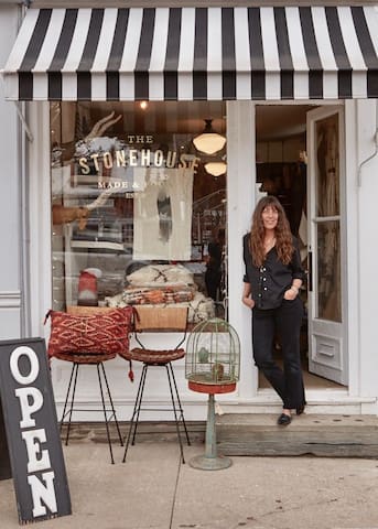
The Stonehouse
92 Main StTiny boutique filled with found objects and handcrafted goods collected from around the world
Blue Bee Cafe
114 Main StPrice Chopper
165 Delaware AveRite Aid
94 Chestnut StO'Neill's Shire Pub
123 Main StA swimming hole is found if you drive past Price Chopper on Sherwood Road. You will soon reach a bridge where you can park and go down to a nice swimming hole at the West Branch of the Delaware River.
Sherwood Road
Sherwood RoadA swimming hole is found if you drive past Price Chopper on Sherwood Road. You will soon reach a bridge where you can park and go down to a nice swimming hole at the West Branch of the Delaware River.
Event space in Delhi. Yoga classes, art shows, music performances, clothing swops and every 3 months a fabulous pop up hair salon. Check their website for more info.
20 polecane przez mieszkańców

Bushel Collective
106 Main StEvent space in Delhi. Yoga classes, art shows, music performances, clothing swops and every 3 months a fabulous pop up hair salon. Check their website for more info.
O'Connor Hospital: Emergency Room
460 Andes RdHollow
Antiques, food. The owner cooks a pop up lunch on Saturday's as long as weather permits.
26 polecane przez mieszkańców
This and That
110 Main StAntiques, food. The owner cooks a pop up lunch on Saturday's as long as weather permits.
Luck Dragon
art supplies and workshops
Hobart
Hobart is a 9-minute drive where you'll find 5 bookstores in this tiny village plus a great wine store, a diner, English pub and farmers' market on Fridays from 4-7pm.
Cellar Door Wines and Spirits
Organic, biodynamic, sustainably-made wines and spirits.
Coffee Pot
581 E Main Stdiner
Unadilla
Unadilla is a 50-minute drive but has an outdoor drive-in movie in addition to antique stores.
Great movies, great prices, great food and fun! Brand New Super Sharp Digital Projector , New Screen has been installed, new snack bar renovation & bathrooms.
https://www.drive-in.ws/
14 polecane przez mieszkańców
Unadilla Drive-In
1706 NY-7Great movies, great prices, great food and fun! Brand New Super Sharp Digital Projector , New Screen has been installed, new snack bar renovation & bathrooms.
https://www.drive-in.ws/
Stamford
Stamford is a 15-minutes drive and has a local butcher shop, diner, thrift store and hiking trail up Mount Utsayantha. There's some nice old Victorian houses to see as you walk around town.
Solinksy's Smokehouse is a delicatessen specializing in charcuterie, smoked meats, and fresh sausage.
28 polecane przez mieszkańców
Solinsky's
103 Main StSolinksy's Smokehouse is a delicatessen specializing in charcuterie, smoked meats, and fresh sausage.
T P's Cafe
7 Railroad AveServes breakfast and lunch
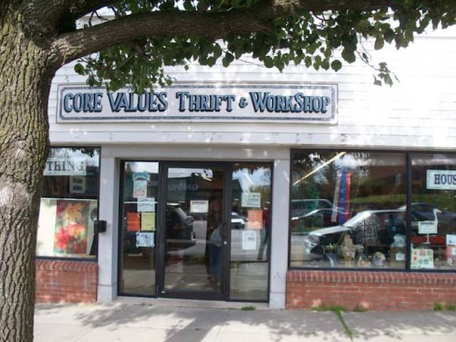
Core Values Inc
112 Main StThrift store open Wed-Fri 11-4, Sat 11-3.
Hike on a dirt road or drive up to the top. Along the way, you will see a granite marker for the alleged burial location of the local Indian maiden, Utsayantha.
When you reach the top, there are several viewpoints. One is from a wooden platform used by hang-gliding enthusiasts.
Directions: NY 23 east from the village of Stamford, right on Mountain Avenue. This road will become extremely steep. There is a dirt road on the left as you crest the ridge, which is Tower Road. You'll see a sign for the park on the corner. Park in this area if you are planning to hike the road as there are a few private driveways' prior to the main climb up to the Fire Tower. The GPS coordinates are N42 23.581 W74 35.969 of the start of Tower Road.
104 polecane przez mieszkańców
Mount Utsayantha Fire Tower
Hike on a dirt road or drive up to the top. Along the way, you will see a granite marker for the alleged burial location of the local Indian maiden, Utsayantha.
When you reach the top, there are several viewpoints. One is from a wooden platform used by hang-gliding enthusiasts.
Directions: NY 23 east from the village of Stamford, right on Mountain Avenue. This road will become extremely steep. There is a dirt road on the left as you crest the ridge, which is Tower Road. You'll see a sign for the park on the corner. Park in this area if you are planning to hike the road as there are a few private driveways' prior to the main climb up to the Fire Tower. The GPS coordinates are N42 23.581 W74 35.969 of the start of Tower Road.
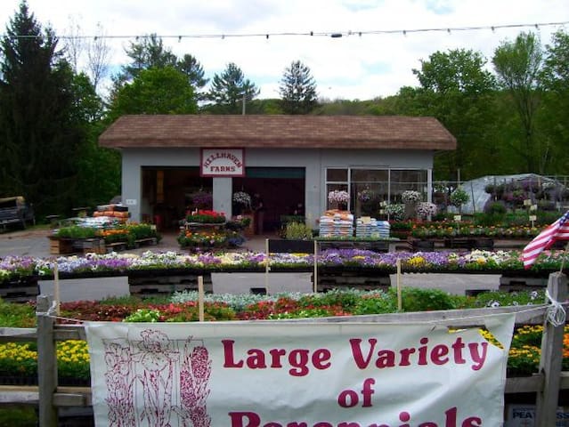
Hillhaven Farms
2 Hobart RdFarm stand
The Antique Knot
74 Main StBeautiful antique rugs
Franklin
Franklin is a 42-minute drive and has theater, antiques and shopping.
Franklin Stage Co
25 Institute StProfessional theater, reservations recommended.
The Tulip and the Rose Cafe
435 Main StKabinett & Kammer
422 Main StAntiques